


Description
Medium: Engraving/etching on hand laid (verge) paper.
Sheet size: 17.8 x 15.3 cm (7.01 x 6.02 inch). Image size: 15.4 x 10.6 cm. (6.06 x 4.17 inch).
Condition: very good, given age. General age-related toning and/or occasional minor defects from handling. Please study scan carefully.
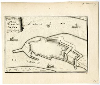
SCHENKENSCHANZ-SCHENKENSCHANS-GERMANY | E24-02
BACKGROUND INFORMATION
This plan was published in France c. 1690.
Biography artist: Nicolas de Fer (1646-1702) was a French cartographer and engraver, as well as map publisher. He made a large number of maps, sometimes of questionable geographic quality, but always with a certain artistic flair.


Reviews
There are no reviews yet.