


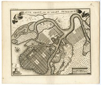
Description
Medium: Copper engraving on hand-laid (verge) paper.
Sheet size: 24.1 x 19.9 cm (9.49 x 7.83 inch). Image size: 19.3 x 16.5 cm. (7.6 x 6.5 inch).
Condition: very good, given age. Double fold as published, light foxing, creasing and soiling. General age-related toning and/or occasional minor defects from handling. Please study scan carefully.
SAINT PETERSBURG, RUSSIA, ISAAK TIRION, 18TH-CENTURY CITY PLAN, URBAN DEVELOPMENT, ANTIQUE MAP, FORTIFICATIONS, KRONSTADT, NEVA RIVER | PCO-E19-48
BACKGROUND INFORMATION
From Isaak Tirion’s “Hedendaagsche Historie of Tegenwoordige Staat van Alle Volkeren” (vol. 7, 1735).
Biography engraver: Isaak Tirion (1705-1765) was a Dutch publisher based in Amsterdam. He is known for his historical reference works, including “Hedendaagsche Historie” and “Vaderlandse Historie”, both of which included detailed maps and engravings. His maps were widely respected for their accuracy and artistic quality.

Reviews
There are no reviews yet.