


Description
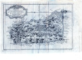
This print shows a view on a map of Saint Lucia, an independent island nation in the Caribbean. The island, which has a land area of 606 km? and has a population of 166,487, belongs to the Windward Islands and is located north of Saint Vincent and the Grenadines and south of Martinique.
Made by Jacques Nicolas Bellin after Prevost.
Medium: Engraving on handlaid (verge) paper.
Sheet size: 35.5 x 26 cm (13.98 x 10.24 inch). Image size: 30 x 21.5 cm. (11.81 x 8.46 inch).
Condition: good, given age. Folds as published. Extra folds. Paper loss upper margin. General age-related toning and/or occasional minor defects from handling. Please study scan carefully.
SAINT LUCIA-ISLAND-CARRIBEAN-WINDWARD ISLAND | RBOS-A10-34
BACKGROUND INFORMATION
This attractive print was published in Prevost’s “Histoire Generale des Voyages” 1758.
Biography engraver: Jacques Nicolas Bellin (1703 ? 21 March 1772) was a French hydrographer, geographer, and member of the French intellectual group called the philosophes.
Bellin was born in Paris. He was hydrographer of France’s hydrographic office, member of the Academie de Marine and of the Royal Society of London. Over a 50-year career, he produced many maps of particular interest to the Ministere de la Marine. His maps of Canada and of French territories in North America (New France, Acadia, Louisiana) are particularly valuable. He died at Versailles.

Reviews
There are no reviews yet.