


Description
Medium: Etching / engraving on hand laid (verge) paper.
Sheet size: 74 x 35 cm (29.13 x 13.78 inch). Image size: 68 x 24.5 cm. (26.77 x 9.65 inch).
Condition: very good, given age. Original folding as issued. Printed on 2 plates joint at the center. Some creasing. Small tear in left paper. Paper septation at top right fold margin, backed. General age-related toning and/or occasional minor defects from handling. Please study scan carefully.
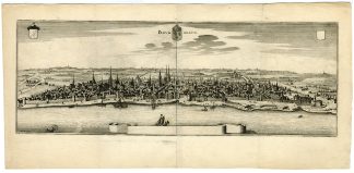
PANORA-VIEW-BORDEAUX-FORTIFICATIONS | PCOLOEF
BACKGROUND INFORMATION
From one of the 21 volumes of ‘Theatrum Europaeum (..)’ by C. Merian, published in Frankfurt c. 1652. This work was started by his father Matthaeus in 1635 whom he succeeded with his brother Matthaeus the younger in 1650.
Biography engraver: Caspar Merian (1627-1686) was in important engraver and publisher from Frankfurt am Main. He was the son of Matthaeus Merian the elder (1593-1650) and Maria Magdaleda de Bry.

![Antique Print - SURGEON-CHIRURGYN - [Jan Luyken or Luiken-c.1720]](https://pictura-prints.com/wp-content/uploads/2019/09/pcor0902-324x385.jpg)
![Antique Print - Kanselarij-Court House-Leeuwarden [after C. Pronk, 1754]](https://pictura-prints.com/wp-content/uploads/2019/08/pco-7362-324x270.jpg)

Reviews
There are no reviews yet.