


Description
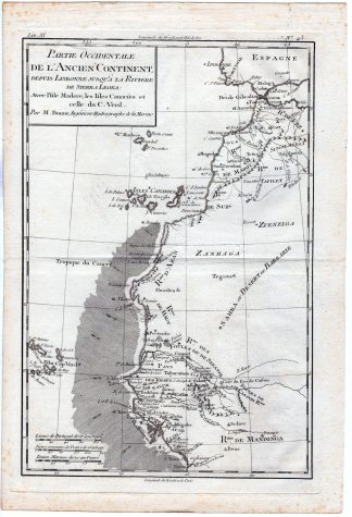
This print shows a view on a map of the north-west coast of Africa from Lisboa till Sierra Leone. We see the islands of Madeira, Cape Verd islands and the Canary islands. It provides a detailed view of the coastlines and significant inland features, which were crucial for trade and exploration. The prime meridians used are Ferro and Paris, reflecting the European perspective and navigational standards of the time.
Made by an anonymous engraver after Rigobert Bonne.
Medium: engraving on wove paper.
Sheet size: 25 x 37 cm (9.84 x 14.57 inch). Image size: 21 x 31.5 cm. (8.27 x 12.4 inch).
Condition: good, given age. Fold as published. Brown spots. . General age-related toning and/or occasional minor defects from handling. Please study scan carefully.
MAP-NW COAST AFRICA-SIERRA LEONE-MADEIRA-CANARY ISLANDS-CAPE VERDE-SAHARA | RBOS-A10-38
BACKGROUND INFORMATION
This attractive print was published as part of the atlas accompanying “Histoire Philosophique et Politique Des Etablissements et Du Commerce Des Europeens Dans Les Deux Indes” by G.T. Raynal and R. Bonne in 1780. .
Biography artist: Rigobert Bonne, an engineer and hydrographer for the French Navy.

Reviews
There are no reviews yet.