

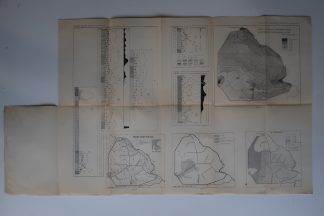
Description
Several maps and schemes related to the development of the Noordoost Polder in the Netherlands.
Made by an anonymous engraver after j. Muller and B. van Raadshooven.
Medium: Lithograph on wove (vellin) paper.
Image size: 59 x 43 cm. (23.23 x 16.93 inch).
Condition: good, given age. Original folds as issued. General age-related toning and/or occasional minor defects from handling. Please study scan carefully.
NOORDOOST POLDER-MAPS AND SCHEMES | PCO-B5-24
BACKGROUND INFORMATION
Source: ‘Tijdschrift van het Koninklijk Nederlandsch Aardrijkskundig Genootschap’, a periodical published from 1888-1966, initially published by C.F. Stemler and later by Brinkman/Beijers (from 1879) and Brill (from 1894). This item dates from 1947.


Reviews
There are no reviews yet.