

Description
Original colour lithographs. on paper.
Size in cm: The overall size is ca. 30.7 x 24.4 cm. The image size is ca. 27.3 x 22.3 cm. Size in inch: The overall size is ca. 12.1 x 9.6 inch. The image size is ca. 10.7 x 8.8 inch.
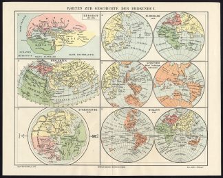
Map: ‘Karten zur Geschichte der Erdkunde I.’ (The history of Maps / Mapmaking). This original map originates from the 6th edition of Meyers’ Konversationslexikon. This edition was published 1902-1920, but the same prints were used for other editions and similar publications, such as the Brockhaus encyclopedia and the Dutch encyclopedias Winkler Prins and Oosthoek.Artists and Engravers: The original founder and publisher who initiated this famous enxyclopedia was Joseph Meyer (1796-1856, Hildburghausen, Germany).
Condition: Excellent. Middle fold, as issued. General age related toning and occasional light staining from handling as visible on image.
Keywords: ANTIQUE MAP-MAPS-MAP MAKING-PTOLEMY-HOMANN-MEYERS
(PCOMAN) A172-16


![[Hubertus QUELLINUS] Ornamental decoration: masks, spinning, agriculture (Amsterdam City Hall)](https://pictura-prints.com/wp-content/uploads/2018/07/pcom_0330-324x483.jpg)

Reviews
There are no reviews yet.