

Description
Original copper engraving on a vellin type paper. on paper.
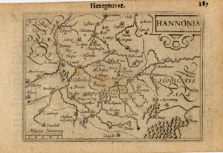
Size in cm: The overall size is ca. 17.5 x 10.5 cm. The image size is ca. 12 x 9 cm. Size in inch: The overall size is ca. 6.9 x 4.1 inch. The image size is ca. 4.7 x 3.5 inch.
Map: ‘Hannonia.’ (Map of Hainaut.) This miniature map shows the county of Hainaut in Belgium. With scale. Map by Bertius (published by Hondius) ca. 1616.Artists and Engravers: Petrus Bertius (Bert) was a Flemish theologian, historian, geographer and cartographer grown up in Beveren (Flanders). In 1593 he became a librarian and professor of mathematics at the University of Leyden. His main cartographic works are a miniature world atlas of 1600, a pocket atlas dedicated to the architecture, the maps and the views of towns of the German Empire of 1616 (26 engraved maps and 101 town views) and a version of Ptolemy’s Geographia containing 28 maps engraved by Mercator for his 1578 edition and 14 maps of Ortelius’ Parergon.
Condition: Excellent. General age related toning and occasional light staining from handling as visible on image.
Keywords: ANTIQUE MAP-HANNONIA-HAINAUT-HENEGOUWEN-BELGIUM-BERTIUS-HONDIUS
PCOX-C3-14

Reviews
There are no reviews yet.