

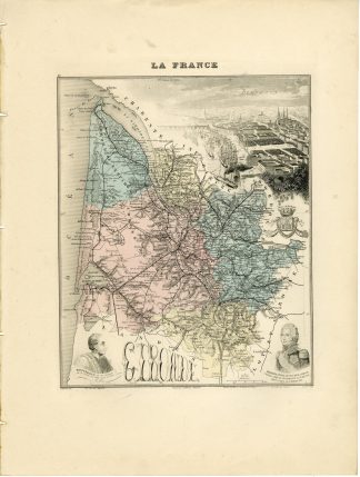
Description
Medium: Steel engraving with original hand colouring on wove (vellin) paper.
Sheet size: 26.7 x 40.6 cm (10.51 x 15.98 inch). Image size: 26.5 x 38.1 cm. (10.43 x 15 inch).
Condition: good, given age. Light foxing, creasing, and soiling. Remains of holes at top from binding. General age-related toning and/or occasional minor defects from handling. Please study scan carefully.
ANTIQUE MAP FRANCE DEPARTEMENT 1890 FRENCH ATLAS MIGEON CITY VIEW PORTRAIT ENGRAVING
BACKGROUND INFORMATION
From “Nouvel Atlas Illustre: La France et ses colonies”, published ca. 1890 by Migeon.
Biography engraver: Fillatreau, Raynaud, Varinot and Barbier were 19th-century French engravers.
Biography artist: Alexandre Aime Vuillemin (1812-1880) was an engraver, publisher, and editor based in Paris, France in the middle of the 19th century. Despite a prolific publishing career, much of Vuillemin’s life is shrouded in mystery. In 1852, he married Josephine Caroline Goret and they had at least one child, Ernestine Ad?le Vuillemin, later in the same year. What is known is that his studied under the prominent French Auguste Henri Dufour (1798 – 1865). Vuillemin’s most important work his detailed, highly decorative large format Atlas Illustre de Geographie Commerciale et Industrielle.

![Rare book [by LAMBRECHTSEN VAN RITTHEM, Nicolaas Cornelis] - (USA) ACCOUNT OF DUTCH AMERICA - NEW YORK [Middelburg, 1818]](https://pictura-prints.com/wp-content/uploads/2019/10/IMG_2383-324x418.jpg)

Reviews
There are no reviews yet.