


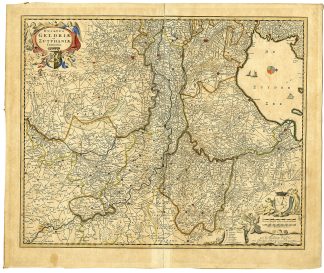
Description
Medium: Copper engraving on hand-laid (verge) paper.
Sheet size: 56 x 46.5 cm (22.05 x 18.31 inch). Image size: 56 x 46 cm. (22.05 x 18.11 inch).
Condition: very good, given age. Light foxing, creasing and soiling. Original middle fold as issued with some paper separation, backed. Paper edges with tape on rear. General age-related toning and/or occasional minor defects from handling. Please study scan carefully.
GELDERLAND MAP, ZUTPHEN MAP, DUTCH HISTORICAL MAPS, NICOLAES VISSCHER II, 17TH-CENTURY CARTOGRAPHY, NETHERLANDS MAPS | MAPS-NETHERLAND-OVERSIZE
BACKGROUND INFORMATION
Originally based on the 1628-1630 maps by Nicolaas van Geelkercken, published by Nicolaes Visscher II around 1690. This ed. by P. Schenk junior.
Reference: KB catalogue, 353012750.
Biography engraver: Nicolaes Visscher II (1649-1702) was a prominent Dutch cartographer, continuing the legacy of the Visscher family. He published numerous maps, including reissues of earlier works, often with enhancements and elaborate decorations.
Biography artist: Nicolaas van Geelkercken (c. 1585-1656) was a Dutch cartographer and land surveyor. He mapped Gelderland and Zutphen in the early 17th century for Johan Isaksson Pontanus’ history of the region. His maps were later updated and republished by Nicolaes Visscher II.

Reviews
There are no reviews yet.