

Description
Medium: Engraving/etching on hand laid (verge) paper.
Sheet size: 21.5 x 17.7 cm (8.46 x 6.97 inch). Image size: 16 x 13.2 cm. (6.3 x 5.2 inch).
Condition: good, given age. Two minor brown spots in image. Small tear bottom margin, not affecting image. General age-related toning and/or occasional minor defects from handling. Please study scan carefully.
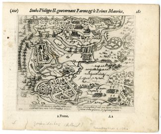
GEERTRUIDENBERG-SIEGE-BATTLE-NETHERLANDS | PCOA55-12
BACKGROUND INFORMATION
This plan originates from: ‘Les guerres de Nassau…’, by G. Baudartius / G. Baudart, published in Amsterdam by M. Colin de Thovoyon in 1616. This important work on the first five decades of the 80 Years War raging in the Netherlands, Belgium and the western part of Germany from 1568-1648, was written from a Contra-Remonstrant point of view. Many of the plates are after ‘Geschichtsblatter’ by Frans Hogenberg and after plates from J. J. Orlers’ work. New plates were added as well.
Biography artist: Publisher: Willem Baudartius (1565-1640) was born in Deinse, Flanders, Belgium, had already fled the Inquisition for England in 1565, together with his family. Returning in 1577 to Ghent, Baudartius had to flee again in 1585, now to the Northern Netherlands, first he went to Leyden and then to Franeker, where he studied Hebrew with Drusius. Baudartius became a minister of the Dutch Reformed Church, at Kampen, Lisse, and Zutphen. In 1619, Baudart was invited by the Synode at Dordrecht to help translate the Bible into Dutch, and he settled in Leyden, where he devoted his life to translating and writing.

Reviews
There are no reviews yet.