

Description
Engraving on verge type hand laid paper with watermark. We absolutely guarantee the authenticity of this item. on paper.
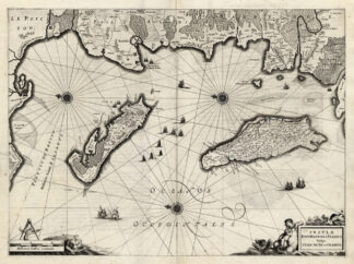
Size in cm: The overall size is ca. 57 x 46 cm. The image size is ca. 53 x 38.5 cm. Size in inch: The overall size is ca. 22.4 x 18.1 inch. The image size is ca. 20.9 x 15.2 inch.
Title: ‘Insulae Divi Martini et Vliarus vulgo L’Isle de Re et Oleron’. This old antique engraved map originates from a rare 2 volume Hondius / Janssonius Atlas: ‘Atlas, das ist, Abbildung der Gantzen Welt ….’, published in 1636 in Amsterdam containing maps by Gerard Mercator, Jodocus and Hendricus Hondius and Johannes Janssonius. (ref: Koeman 1:322). This Atlas contains maps by Mercator, Hondius and early Janssonius edition maps. We carry most maps from the 2nd volume: France, Spain, Portugal, Greece, Mid-East, Asia and America. Review our ebay store, website or inquire for any specific maps not listed.Artists and Engravers: The carthographers / publishers associated with this Atlas are: Gerard Mercator (or Rupelmundanus, Gerard de Kremer, Cremer) (1512-1594), Jodocus Hondius (1563-1612), Henricus Hondius (1597-1651) and Johannes Janssonius (1588-1664). One can find many references in online literature to these famous icons of cartography.
Condition: Fine. general age related toning. some light staining in margins. original middle fold and a few faint false fold lines (can be flattened) from binding. Nice map in fine condition! At your request we can have this map coloured by professional antique map / print colourer (cost inquire).
Keywords: ANTIQUE MAP-FRANCE-ISLE DE RE-OLERON-HONDIUS
(PCO) B15-31

Reviews
There are no reviews yet.