

Description
Engraving on verge type hand laid paper with watermark. We absolutely guarantee the authenticity of this item. on paper.
Size in cm: The overall size is ca. 54 x 44 cm. The image size is ca. 50 x 37.5 cm. Size in inch: The overall size is ca. 21.3 x 17.3 inch. The image size is ca. 19.7 x 14.8 inch.
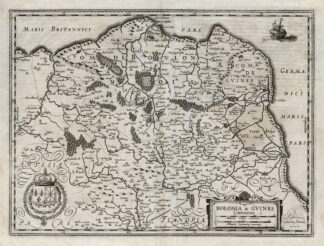
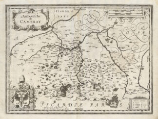
Galliae … descriptio, Henrico Hondio, H. Hondium 1631 (France, Gaul, Gallia) This old antique engraved map originates from a rare 2 volume Hondius / Janssonius Atlas: ‘Atlas, das ist, Abbildung der Gantzen Welt ….’, published in 1636 in Amsterdam containing maps by Gerard Mercator, Jodocus and Hendricus Hondius and Johannes Janssonius. (ref: Koeman 1:322). We carry most maps from the 2nd volume: France, Spain, Portugal, Greece, Mid-East, Asia and America. Review our ebay store, website or inquire for any specific maps not listed.Artists and Engravers: The carthographers / publishers associated wit this Atlas are: Gerard Mercator (or Rupelmundanus, Gerard de Kremer, Cremer) (1512-1594), Jodocus Hondius (1563-1612), Henricus Hondius (1597-1651) and Johannes Janssonius (1588-1664). One can find many references in online literature to these famous icons of cartography.
Condition: Fine. general age related toning. some light staining from handling. original middle fold and a few small fold lines from binding. bottom middle fold is torn, but backed by paper. a few cities are highlighted in yellow by previous historic owners. sheet is numbered with old iron gall ink. back with original german text as issued. At your request we can flatten this map a little further and we can have it coloured by professional antique map / print colourer (cost inquire).
Keywords: ANTIQUE MAP-FRANCE-GALLIAE-HONDIUS-JANSSONIUS
(PCO) B15-01


Reviews
There are no reviews yet.