

Description
Engraving on verge type hand laid paper with watermark. We absolutely guarantee the authenticity of this item. on paper.
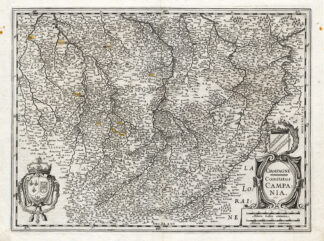
Size in cm: The overall size is ca. 55.5 x 44 cm. The image size is ca. 50 x 37.5 cm. Size in inch: The overall size is ca. 21.9 x 17.3 inch. The image size is ca. 19.7 x 14.8 inch.
Title: ‘Champagne Comitatus Campania’. (Champaign) This maps shows the cities of: Brie, Troyes, Chalons, Verdun, Neufchatel, Varenne, Clermont and others. This old antique engraved map originates from a rare 2 volume Hondius / Janssonius Atlas: ‘Atlas, das ist, Abbildung der Gantzen Welt ….’, published in 1636 in Amsterdam containing maps by Gerard Mercator, Jodocus and Hendricus Hondius and Johannes Janssonius. (ref: Koeman 1:322). We carry most maps from the 2nd volume: France, Spain, Portugal, Greece, Mid-East, Asia and America. Review our ebay store, website or inquire for any specific maps not listed.Artists and Engravers: The carthographers / publishers associated wit this Atlas are: Gerard Mercator (or Rupelmundanus, Gerard de Kremer, Cremer) (1512-1594), Jodocus Hondius (1563-1612), Henricus Hondius (1597-1651) and Johannes Janssonius (1588-1664). One can find many references in online literature to these famous icons of cartography. Iehan Iubrien Chalonnois is indicated on this map as the maker.
Condition: Fine. general age related toning. some light staining in margins from handling. original middle fold from binding. a few tiny pin size holes in margin. small hole close to middle fold backed by paper. back with original german text as issued. A few cities are highlighted by previous owner. At your request we can have this map coloured by professional antique map / print colourer (cost inquire).
Keywords: ANTIQUE MAP-FRANCE-CHAMPAGNE-HONDIUS
(PCO) B15-09


Reviews
There are no reviews yet.