

Description
Copperplate engraving and etching on a verge type hand laid paper. on paper.
Size in cm: The overall size is ca. 67.5 x 51.5 cm. The image size is ca. 58.5 x 51 cm. Size in inch: The overall size is ca. 26.6 x 20.3 inch. The image size is ca. 23 x 20.1 inch.
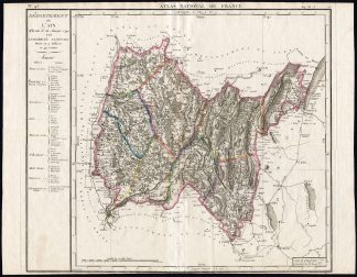
Map: ‘Departement de L’Ain’ (Map of the Ain department, France). Attractive detailed map. This map originates from an unrecorded composite Atlas compiled around 1795 (based on youngest dated map). This map originally published in ‘Atlas national de France.’, Paris, published by Bureau de l’Atlas National, Paris 1793. The Atlas National de France was the culminating achievement of over 100 years of French national surveying carried out by the family Cassini. There were, finally, 182 detailed maps covering all France…. The ‘authors’ of the published version were Dumez and P.G. Chanlaire. A quarto version of the atlas was published first, in 1791, followed by the folio version two years later in 1793. This map originates from the folio edition.Artists and Engravers: Cartographers / surveyors: Cassini family, starting with Jacques Cassini (1677-1756). Author/Geographers: Pierre Dumez (1757-1794) and Pierre-Gilles Chanlaire (1758-1817). Engraver: Francois d�Houdan.
Condition: General age related toning and light staining. Two small worm holes near lower middle fold. Short margin at the bottom. Please study scan carefully.
Keywords: ANTIQUE MAP-FRANCE-AIN DEPARTMENT-SWITZERLAND-CASSINI-CHANLAIRE-DUMEZ
XXX-B3-13

Reviews
There are no reviews yet.