


Description
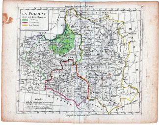
This print shows a view on a map of Poland with its borders to Prusia, Austria and Russia.
Made by an anonymous engraver after Charles-Fran?ois Delamarche.
Medium: engraving on handlaid (verge) paper.
Sheet size: 28 x 21.5 cm (11.02 x 8.46 inch). Image size: 22.3 x 19 cm. (8.78 x 7.48 inch).
Condition: good, given age. Smudges. Bownish edges. Fold as published. Folds in lower corners. Stain in upper left corner. General age-related toning and/or occasional minor defects from handling. Please study scan carefully.
MAP-EUROPE-POLAND-PRUSIA-AUSTRIA-RUSSIA | RBOS-A10-38
BACKGROUND INFORMATION
This attractive print was published from “Petit atlas moderne ..,” with editions in 1790 and 1793.
Biography artist: Charles Fran?ois Delamarche (August 1740-31 October 1817) was a French geographer and mapmaker.
One of the most important French geographers and mapmakers of the second half of the eighteenth century.

Reviews
There are no reviews yet.