


Description
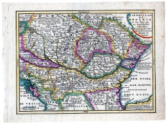
This rare print shows a view on a map of the Kingdom of Hungary.
Made by an anonymous engraver after Jean Rousset de Missy.
Medium: engraving on handlaid (verge) paper.
Sheet size: 25 x 18.8 cm (9.84 x 7.4 inch). Image size: 21.7 x 16.2 cm. (8.54 x 6.38 inch).
Condition: good, given age. Creases. Folds. General age-related toning and/or occasional minor defects from handling. Please study scan carefully.
MAP-EUROPE-KINGDOM OF HUNGARY | RBOS-A10-38
BACKGROUND INFORMATION
This attractive print was from a rare edition. This plate originates from: ‘Nieuwe Astronomische Geographische en Historische Atlas .’, by Jean Rousset de Missy, published in Amsterdam by Hendrik de Leth, not dated, but 1749, rare extended 1st. Dutch edition. From 1770 onwards it was published by S.J. Baalde. Publisher: Hendrik de Leth (Amsterdam, 1703-1766). De Leth was a printmaker and draughtsman of landscapes, active in Amsterdam. He was one of the artists who collaborated on Zegepralent Kennemerland, but also published numerous quite beautiful maps. Engraver, publisher and painter, active in Amsterdam, worked for the Visscher family and eventually took over the business. De Leth is better known as an artist and engraver than as a cartographer although his historical atlas of the Netherlands was a very popular work.
Biography artist: Jean Rousset de Missy (b. Laon, 1686-1762) was a French Huguenot writer, living from early in life in the Netherlands. He was a renowned historian and author on international law and a prolific journalist. .

Reviews
There are no reviews yet.