


Description
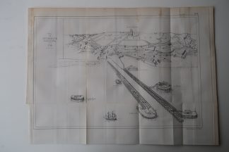
View of the fortified town of Dunkirk/Dunkerque in northern France as it was in 1710.
Made by Anonymous after Revue Maritime.
Medium: Etching / Engraving on wove (vellin) paper.
Sheet size: 42.5 x 31 cm (16.73 x 12.2 inch).
Condition: good, given age. Original folds as issued. Some foxing, which can be removed on request. General age-related toning and/or occasional minor defects from handling. Please study scan carefully.
DUNKIRK-DUNKERQUE-DUINKERKEN-FORT | PCO-B5-01
BACKGROUND INFORMATION
From ‘Revue Maritime et Coloniale’, a periodical published in Paris from 1861-1896 by the French ‘Ministere de la Marine et des Colonies’. This item was published in 1869.

Reviews
There are no reviews yet.