

Description
Etching/Engraving on verge type hand laid paper. Contemporary hand colouring. on paper.
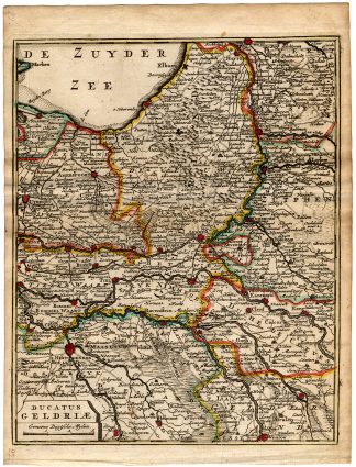
Size in cm: The overall size is ca. 24.5 x 20.5 cm. The image size is ca. 19.5 x 16.5 cm. Size in inch: The overall size is ca. 9.6 x 8.1 inch. The image size is ca. 7.7 x 6.5 inch.
Plate 22 titled: ‘Ducatus Geldriae.’ (New map of Duchy of Gelderland.) French titles. From a rare edition. This plate originates from: ‘Nieuwe Astronomische Geographische en Historische Atlas …’, by Jean Rousset de Missy, published in Amsterdam by Hendrik de Leth, not dated, but 1749, rare extended 1st. Dutch edition. From 1770 onwards it was published by S.J. Baalde (cf. Koeman Baa 1A and Baa 1B). Artists and Engravers: Author: Jean Rousset de Missy (b. Laon, 1686-1762) was a French Huguenot writer, living from early in life in the Netherlands. He was a renowned historian and author on international law and a prolific journalist. Publisher: Hendrik de Leth (Amsterdam, 1703-1766). De Leth was a printmaker and draughtsman of landscapes, active in Amsterdam. He was one of the artists who collaborated on Zegepralent Kennemerland, but also published numerous quite beautiful maps. Engraver, publisher and painter, active in Amsterdam, worked for the Visscher family and eventually took over the business. De Leth is better known as an artist and engraver than as a cartographer although his historical atlas of the Netherlands was a very popular work.
Condition: In good condition given age. Well inked. General age related toning and light staining. Original folding as issued. Please study scan carefully.
Keywords: ANTIQUE MAP-DUCHY OF GELDERLAND-GELRIAE-DE MISSY-DE LETH
PCOX-C1-17

Reviews
There are no reviews yet.