


Description
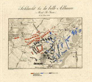
‘SCHLACHT BEI LA BELLE ALLIANCE, DEN 18. JUNI 1815.’
This original antique plate shows the Battle of La Belle Alliance (18 june 1815), an inn situated a few miles south of Brussels in Belgium, chiefly remembered for its significance in the aftermath of the Battle of Waterloo.
Made by Dorneck after von Rothenburg.
Steel engraving on wove (vellin) paper.
Condition: good, given age. Paper slightly browned and some foxing. General age-related toning and/or occasional minor defects from handling. Please study scan carefully.
BATTLE OF LA BELLE ALLIANCE-BELGIUM
PCO-BOX-ROTHENBURG
BACKGROUND INFORMATION
From: ‘Schlachten-Atlas’, by Friedrich Rudolf von Rothenburg, published in 18 ed. from 1837-1853. This work covers plans and descriptions of important military battles that took place between the year 357 (Strassburg) and 1831 (Ostroleka). Exact ed. unknown. Set contains original plan and original descriptive text pages.
Reference: Engelmann 77; Graesse VI.


Reviews
There are no reviews yet.