


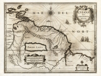
Description
Medium: Engraving with original hand coloring on hand-laid (verge) paper.
Sheet size: 50 x 40.5 cm (19.69 x 15.94 inch). Image size: 32 x 27.5 cm. (12.6 x 10.83 inch).
Condition: good, given age. Light foxing, creasing and soiling. Original vertical fold as issued. General age-related toning and/or occasional minor defects from handling. Please study scan carefully.
AMERICA, 18TH-CENTURY CARTOGRAPHY, ISAAK TIRION, AMSTERDAM MAPS, ANTIQUE MAPS, DUTCH ENGRAVING, COLONIAL AMERICA, HISTORICAL GEOGRAPHY | EXPO-MAPS
BACKGROUND INFORMATION
Published by I. Tirion, Amsterdam, ca. 1750.
Biography engraver: Isaak Tirion (1705-1765) was a Dutch publisher and cartographer based in Amsterdam. He produced various atlases and topographical works, known for their high-quality engravings and geographical accuracy. His maps were often based on the work of leading French cartographer Guillaume de l’Isle.
![FISH-COOKING-GUTTED 'Untitled' [Floris VERSTER, ca. 1900]](https://pictura-prints.com/wp-content/uploads/2018/07/pco_1233-324x370.jpg)


Reviews
There are no reviews yet.