

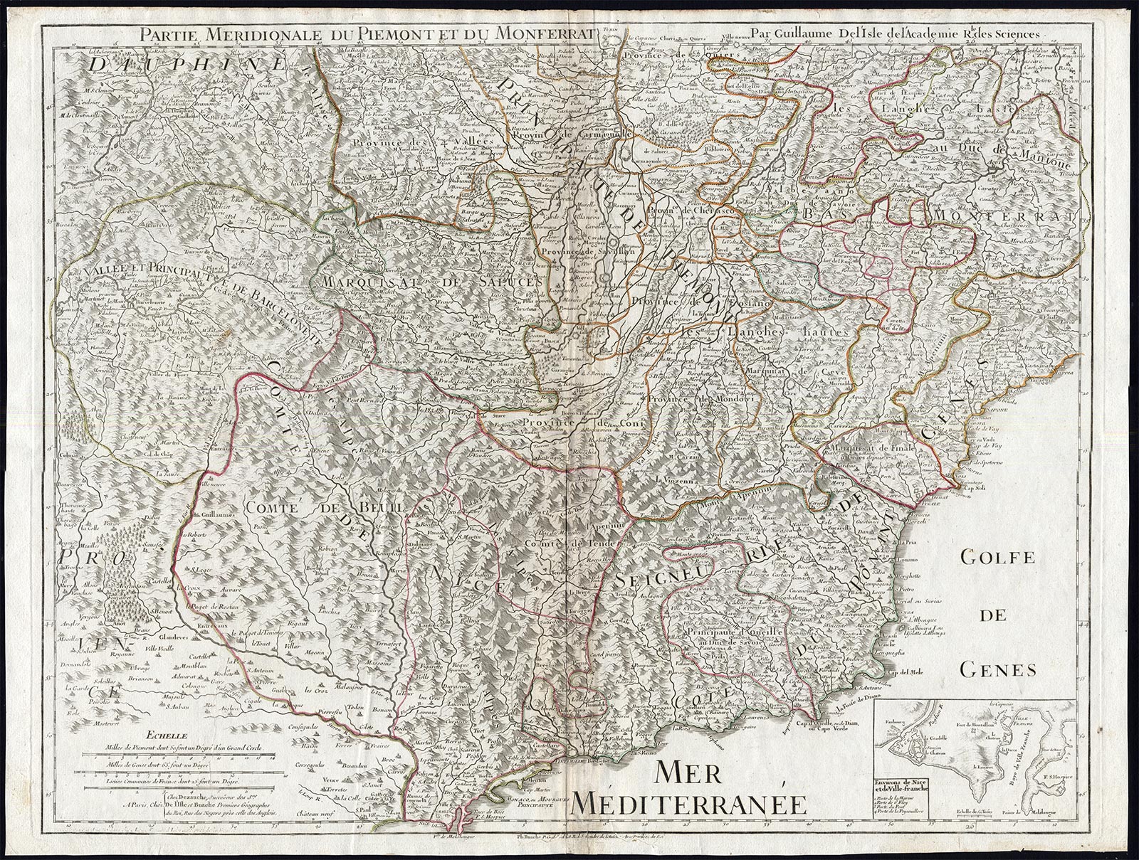
Description
Copperplate engraving and etching on a verge type hand laid paper. on paper.
Size in cm: The overall size is ca. 68 x 51 cm. The image size is ca. 63.5 x 49.5 cm. Size in inch: The overall size is ca. 26.8 x 20.1 inch. The image size is ca. 25 x 19.5 inch.
2 Maps making one large composite map: ‘Carte du Piemont et du Monferrat.’ & ‘Partie Meridionale du Piemont et du Monferrat.’ (Map of Piedmont and Monferrato, Italy). The Alps region of France and Italy. Shows part of the region of Savoy in France and Piedmont in Italy, and includes the towns of Turin (Torino) and Guillestre (France) in the south and Aouste (France) in the north. This map originates from an unrecorded composite Atlas compiled around 1795 (based on youngest dated map). This map was part of ‘Atlas nouveau’, by G. De l’Isle, first published in Amsterdam in 1730. This edition published by J.A. Dezauche, succesor of Guillaume De L’Isle and Philipe Buache (1700-1773). This map age reference in cartouche: 1775.Artists and Engravers: The de Delisle / de L’Isle family was one of the most influential Geographers of the early 18th century in France. Claude de L’Isle, born 1644, had four sons, of which Guillaume was the most notable. Guillaume was born 1675 and became member of the ‘Academie Royale des Sciences’ with the age of twenty-seven, and was honoured later with the title ‘Premier Geographe du Roi’. His largest project, the ‘Atlas de Geographie’, was published until 1774 in Paris and Amsterdam (Covens and Mortier). He died in 1726.
Condition: Map 1: General age related toning and light staining. A few smal worm holes at lower middle fold and bottom margin. Map 2: General age related toning and light staining. Worm holes at lower middle fold and bottom margin. paper separation lower middle fold, backed by identical paper. Irregular paper edges, chipped with small tears backed by identical paper. Please study scans carefully.
Keywords: 2 ANTIQUE MAPS-ITALY-FRANCE-PIEDMONT-MONFERRATO-MONACO-DE L’ISLE-DEZAUCHE
XXX-B3-11
![CLAUDE D'ESTAMPES-PORTRAIT-P.88 'Monsieur d'Estampes' [Lord GOWER after CLOUET, 1875]](https://pictura-prints.com/wp-content/uploads/2018/07/pcom211-324x445.jpg)


Reviews
There are no reviews yet.