


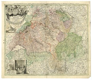
Description
Medium: Etching/Engraving, hand-colored on hand laid (verge) paper.
Sheet size: 60 x 52 cm (23.62 x 20.47 inch). Image size: 56.4 x 48.3 cm. (22.2 x 19.02 inch).
Condition: very good, given age. Bottom right corner torn. Two stains on the middle left margin. Light foxing, creasing and soiling. Original vertical fold as issued. General age-related toning and/or occasional minor defects from handling. Please study scan carefully.
SWITZERLAND, SWISS CANTONS, HELVETIC REPUBLIC, HOMANN, NUREMBERG, 18TH-CENTURY MAPS, HISTORICAL CARTOGRAPHY, COAT OF ARMS, ANTIQUE GEOGRAPHY | MAPS-LARGE
BACKGROUND INFORMATION
Published in 1732, as part of Homann’s famous cartographic series.
Biography engraver: Johann Baptist Homann (1663-1724) was a renowned Bavarian cartographer and founder of Homann Heirs, a dominant map publishing house in Germany. Appointed Imperial Geographer to the Holy Roman Empire, he gained imperial printing privileges and produced some of the most sought-after maps of the 18th century. His works were known for fine engraving, accuracy, and artistic cartouches. Homann’s business passed to his son, Christoph (1703-1730), and later to the Homann Heirs. The firm continued to publish maps until 1848, influencing European mapmaking traditions.
![VII-New Zealand-Mercury Bay-Tolaga-Islands Bay [After COOK, 1795]](https://pictura-prints.com/wp-content/uploads/2019/01/pco-2664-324x236.jpg)


Reviews
There are no reviews yet.