


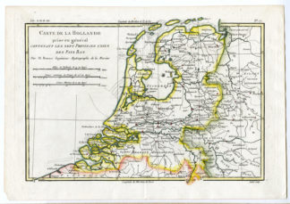
Description
Medium: Copper engraving on Hand-laid (verge) paper.
Sheet size: 40 x 36.5 cm (15.75 x 14.37 inch). Image size: 36.3 x 34.3 cm. (14.29 x 13.5 inch).
Condition: very good, given age. Original fold lines as issued. General age-related toning and/or occasional minor defects from handling. Please study scan carefully.
AMERICA, ANTIQUE MAPS, ISAAK TIRION, 18TH-CENTURY CARTOGRAPHY, DUTCH MAPS, NORTHWEST PASSAGE, COLONIAL GEOGRAPHY, HISTORICAL MAPS | EXPO-MAPS
BACKGROUND INFORMATION
Published by I. Tirion, Amsterdam, 1754.
Biography engraver: Isaak Tirion (1705-1765) was a Dutch publisher and cartographer based in Amsterdam. He was known for his historical atlases and geographical works, particularly his detailed and well-engraved maps. His works were often influenced by the cartography of Guillaume de l’Isle.


Reviews
There are no reviews yet.