


Description
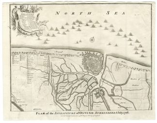
This print shows a map of the View of the City of Ostend in Belgium. A military map showing battle lines and positions, contours and geographical features such as buildings, fortifications, fields and rivers. Ships in the North Sea.
Made by after an anonymous artist.
Medium: Engraving on hand laid (verge) paper.
Sheet size: 51 x 40 cm (20.08 x 15.75 inch). Image size: 47.5 x 38 cm. (18.7 x 14.96 inch).
Condition: good, given age. Folds as published. Creasing in upper margin and upper right corner. Paper separation at top and bottom fold, backed. General age-related toning and/or occasional minor defects from handling. Please study scan carefully.
BATTLE-OSTEND-BELGIUM-MILITARY MAP-BATTLE LINES-SHIPS | RB-T.29-LARGE
BACKGROUND INFORMATION
This attractive print was published by Knapton, John and Paul, London, 1744. From Thomas Rapin’s History of England.


Reviews
There are no reviews yet.