

Description
Copperplate engraving on verge type hand laid paper with watermark. on paper.
Size in cm: The overall size is ca. 51 x 42 cm. The image size is ca. 48 x 39.5 cm. Size in inch: The overall size is ca. 20.1 x 16.5 inch. The image size is ca. 18.9 x 15.6 inch.
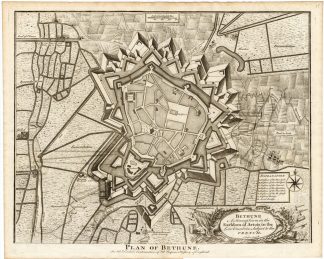
Map : ‘Bethune, a strong town in the Earldom of Artois …’. (Groundplan of Bethune in the Earldom of Artois.) Groundplan with fortifications of Bethune in France (Former Belgian town). This map was engraved for ‘Mr. Tindal’s Continuation of Mr. Rapin’s ‘History of Engand.’ , with maps by Richard William Seale and John Basire, published by Rapin & Tindal. This antique map was printed in 1727 or later. This work was a continuation of ‘L’Histoire d’Angleterre’ by Paul de Rapin-Thoyras, printed at the Hague in 1724. All 13 volumes of his work were translated and continued to English in the early 18th century by the Reverend Nicolas Tindal and first published in 1727. As time went on more volumes were added with more recent history.Artists and Engravers: Authors: Nicholas Tindal (1687-1774) and Paul de Rapin-Thoyras (1661-1725), a French historian working under English patronage. Engraved by Isaac Basire (1704-68). Many sources mention James Basire being the engraver, but he was born in 1730.
Condition: Excellent. general age related toning. some light staining from handling.
Keywords: ANTIQUE MAP-BETHUNE-FRANCE-TINDAL
XXX-B1-41

Reviews
There are no reviews yet.