


Description
Engraving on hand laid paper. Watermark: French Lily on paper.
Size in cm: The overall size is ca. 39.2 x 52 cm. The image size is ca. 37.2 x 46.8 cm. Size in inch: The overall size is ca. 15.4 x 20.5 inch. The image size is ca. 14.6 x 18.4 inch.
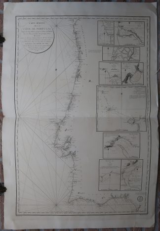
Antique map, titled: ‘A correct Chart of the Bay of Biscay […].’ – A map of the coast of Spain and Portugal, as well as part of France (up to Bretagne/Brittany). The map features numerous coastal towns, as well as Madrid. The Strait of Gibraltar is indicated, as well as the northern point of Africa. With a decorative cartouche and compass rose. According to the title cartouche, “For mr. Tindal’s Continuation of Mr. Rapin’s History”, which is ‘The Continuation of Mr. Rapin’s History of England’, London, 1744-1747.Artists and Engravers: Made by ‘R.W. Seale’ after own design.
Condition: Good, given age. Original folds, as issued. Two stains in the image area, and a small dampstain in the top margin. Minimal paper loss in the lower left corner (very slight loss of image border), backed with paper. A few tiny (binding?) holes in the lower margin. General age-related toning and/or occasional minor defects from handling. Please study scan carefully.
Keywords: ANTIQUE MAP-BAY OF BISCAY-SPAIN-ATLANTIC-SEA CHART-SEALE
(PCO) GK-354


Reviews
There are no reviews yet.