


Description
Engraving on hand laid paper. on paper.
Size in cm: The overall size is ca. 64.7 x 49.4 cm. The image size is ca. 57.9 x 39.6 cm. Size in inch: The overall size is ca. 25.5 x 19.4 inch. The image size is ca. 22.8 x 15.6 inch.
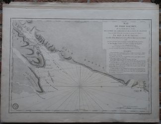
Antique map, titled: ‘Plan du Port Dauphin, de la Rade de Ste. Anne, de l’Entrée de Labrador et de la Baie de Niganiche.’ – A decorative map/chart of the coast of Cape Breton Island, Nova Scotia, Canada. This includes Cape Dauphin, Englishtown (Saint-Anne / Port Dauphin). The West-oriented map shows depth soundings along the coast. A scarse map as we do not see it offered anywhere. Published by Antoine de Sartine, comte d’Alby (1729-1801), ‘Depot General de la Marine’. Based on the 1733 map by Boucher from the “Depot des Plans de la Marine”, 1778.Artists and Engravers: Made by ‘Petit’ after an anonymous artist.
Condition: Very good, given age. The margins browned and with some stains. Two small stains in the left margin (not affecting image). Some small stains in the image. A strip of contemporary paper is attached to the rear of the top margin (possibly for binding purposes). General age-related toning and/or occasional minor defects from handling. Please study scan carefully.
Keywords: ANTIQUE MAP-SEA CHART-CANADA-CAPE BRETON-NOVA SCOTIA-SARTINE-PETIT
(PCO) GK-279

![TRADING POSTS-AMBON-INDONESIA-MOLUCCAS [After VALENTIJN-VOC, 1724]](https://pictura-prints.com/wp-content/uploads/2019/02/pcom-10070-324x267.jpg)


Reviews
There are no reviews yet.