


Description
Engraving, hand coloured on hand laid paper. on paper.
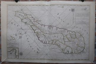
Size in cm: The overall size is ca. 96.2 x 62.9 cm. The image size is ca. 84.5 x 56.5 cm. Size in inch: The overall size is ca. 37.9 x 24.8 inch. The image size is ca. 33.3 x 22.2 inch.
Antique map, titled: ”Carte Particuliere de l”Isle Dauphine ou Madagascar et St. Laurens.” – Detailed map of the island Madagascar and the surrounding islands. With an inset map of the bay near Saint-Augustin. Published by Covens and Mortier (Amsterdam), c. 1695 These type of charts are scarse as they were actually used at sea for navigation.Artists and Engravers: Made by ‘Covens & Mortier (publ.)’ after an anonymous artist. Pieter and David Mortier were booksellers in Paris and have published a wide range of geographical works. After Pieter’s death, his widow continued the business until their son Cornelius took over. Cornelius started a partnership with his brother-in-law Johannes Covens (1697-1774) and established the famous publishing house “Covens and Mortier” in Amsterdam. They have re-issued Atlases of Sanson, de l’Isle, Visscher and de Wit.
Condition: Very good, given age. Map printed from two sheets, joined together. Original middle fold, as issued. Discolouration around the image (from previous matting). A few small creases and scattered stains. General age-related toning and/or occasional minor defects from handling. Please study scan carefully.
Keywords: ANTIQUE MAP-SEA CHART-MADAGASCAR-SAINT AUGUSTIN-COVENS & MORTIER
(PCO) GK-167

Reviews
There are no reviews yet.