
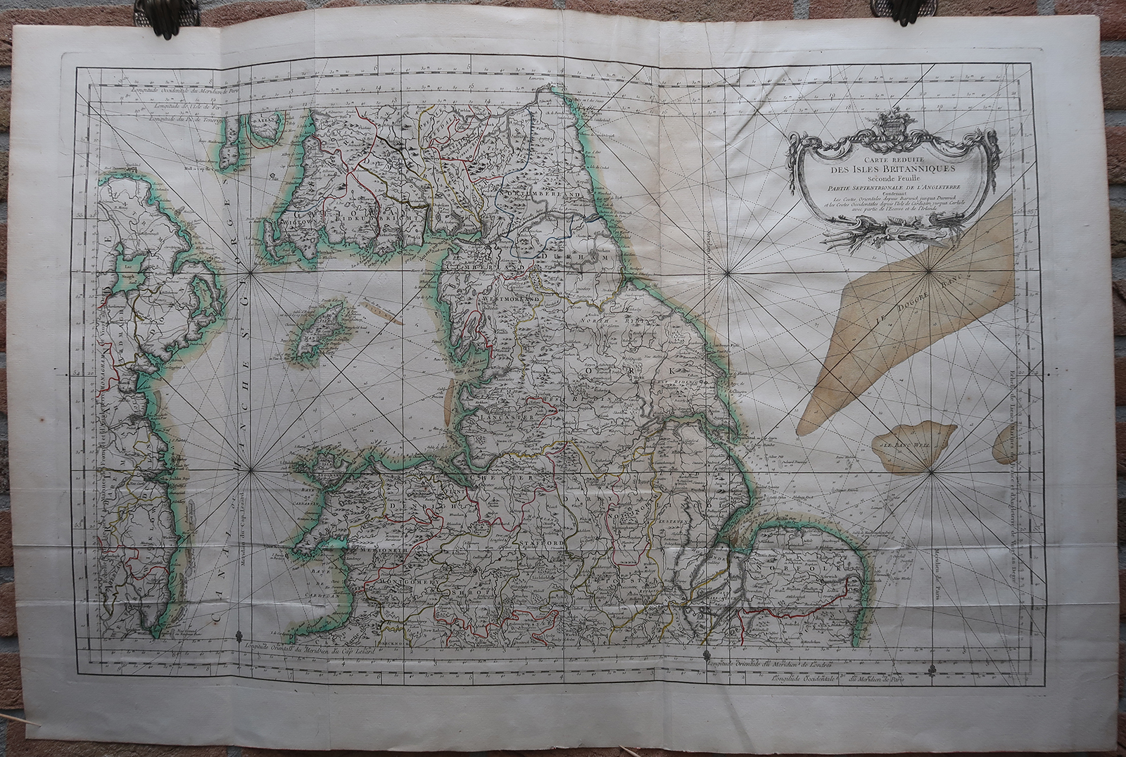
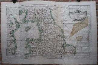
Description
Engraving, handcoloured on hand laid paper. on paper.
Size in cm: The overall size is ca. 98.6 x 65.2 cm. The image size is ca. 86.7 x 55.2 cm. Size in inch: The overall size is ca. 38.8 x 25.7 inch. The image size is ca. 34.1 x 21.7 inch.
Antique map, titled: ‘Carte Reduite des Isles Britanniques Seconde Feuille, Partie Septentrionale de l’Angleterre […].’ – A sea chart/map of Northern England, Wales, the Isle of Man and the Eastern edge of Ireland. The inland area is depicted in detail, with towns, rivers, geographical features. Two meridians, depth soundings and the locations of sand banks are indicates. A decorative cartouche. Published by the Depot de la Marine. From: ‘L’Hydrographie Francoise Recueil des Cartes Generales et Particulieres qui ont ete Faites pour le Service des Vaisseaux du Roy. Par ordre des Ministres de la Marine depuis 1737. jusqu’en 1765.’ Par le S. Bellin Ingenieur de la Marine et du Depost des Cartes, Plans et Journaux de la Marine, Censeur Royal, de l’Academie de Marine et de la Societe Royale de Londres.Artists and Engravers: Made by an anonymous engraver after ‘Jacques-Nicolas Bellin’. Jacques-Nicolas Bellin (1703-1772) was one of the most important cartographers of the 18th century. With a career spanning some 50 years, Bellin is best understood as geographe de cabinet and transitional mapmaker spanning the gap between 18th and early 19th century cartographic styles. His long career as Hydrographer and Ingénieur Hydrographe at the French Dépôt des cartes et plans de la Marine resulted in hundreds of high quality nautical charts of practically everywhere in the world.
Condition: Very good, given age. Original folds, as issued. Creases along some of the folds. The sheet browned along the rightmost vertical fold. Some creasing and small stains in the margins. General age-related toning and/or occasional minor defects from handling. Please study scan carefully.
Keywords: ANTIQUE MAP-SEA CHART-ENGLAND-ISLE OF MAN-WALES-BELLIN-DEPOT DE LA MARINE
(PCO) GK-055

![Animantia cuncta dei opus [Johann SCHEUCHZER after PINTZ, 1731]](https://pictura-prints.com/wp-content/uploads/2018/10/pcom-633-324x472.jpg)
![ANNE DE ROTTELIN D'ESTAMPES-PORTRAIT-P.87 'Madame d'Estampes, fille' [Lord GOWER after CLOUET, 1875]](https://pictura-prints.com/wp-content/uploads/2018/07/pcom210-324x444.jpg)

Reviews
There are no reviews yet.