

Description
Lithograph on wove paper. on paper.
Size in cm: The overall size is ca. 33.1 x 24.8 cm. The image size is ca. 30.6 x 20.9 cm. Size in inch: The overall size is ca. 13 x 9.8 inch. The image size is ca. 12 x 8.2 inch.
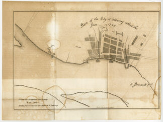
Antique print, titled: ‘Plan of the city of Albany about the year 1770.’ – Lithographic reproduction of a manuscript plan of Albany on the banks of the Hudson river, with annotations, made in 1770 by Robert Yates. This is a lithographically made map from ca. 1849. “Maps in the offices of Secr. Of State and Surveyor General”, Albany: Richard H. Pease, ca. 1850. Cartographers were David Vaughan, E.O. Olmsted and M.E. Seymour.Artists and Engravers: Made by ‘Richard H. Pease’ after ‘Robert Yates’. Printer / publisher: Richard H. Pease (1813-1869) was an engraver / lithographer and printer from Albany.
Condition: Good, given age. Original folds as issued. Sheet quite browned, and with dampstains. General age-related toning and/or occasional minor defects from handling. Please study scan carefully.
Keywords: ANTIQUE PRINT-ALBANY-HUDSON RIVER-PLAN-USA-YATES-PEASE
(PCO) C130-22

Reviews
There are no reviews yet.