


Description
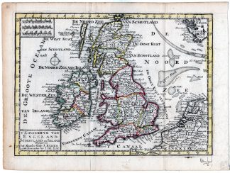
This print shows a view on a map of Great Britain and Ireland. The Netherlands to the right.
Made by an anonymous engraver after de Lat.
Medium: engraving on handlaid (verge) paper.
Sheet size: 27.5 x 20.5 cm (10.83 x 8.07 inch). Image size: 24 x 17.5 cm. (9.45 x 6.89 inch).
Condition: good, given age. Folds as published. Signature in lower right corner. Brown spots. Creases in right corner. General age-related toning and/or occasional minor defects from handling. Please study scan carefully.
MAP-ENGLAND-SCOTLAND-IRELAND-NETHERLANDS | RBOS-A10-38
BACKGROUND INFORMATION
This attractive print was published by J. Keizer and I. de Lat in 1735. This map was later published unaltered by Nicolas Theodorus Gravius after 1777 and Stephanus Jacobus Baalade in 1788.

Reviews
There are no reviews yet.