


Description
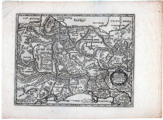
This print shows a view on a map of Poland and eastern Germany in classical antiquity. It’s a very detailed map.
Made by an anonymous engraver after Philipp Cluver.
Medium: engraving on handlaid (verge) paper.
Sheet size: 32.7 x 24.8 cm (12.87 x 9.76 inch). Image size: 25 x 19.5 cm. (9.84 x 7.68 inch).
Condition: good, given age. Brown left margin. Folds all corners. . General age-related toning and/or occasional minor defects from handling. Please study scan carefully.
MAP-EUROPE-POLAND-EAST GERMANY-ANTIQUITY | RBOS-A10-38
BACKGROUND INFORMATION
This attractive print was published in “Introductio in Universam Geographiam” by Cluver1661, Amsterdam.
Biography artist: Philipp Cluver (1580 ? 31 December 1622) was an Early Modern German geographer and historian.

Reviews
There are no reviews yet.