


Description
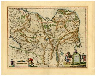
This print shows a view on a map of Tartary, a term historically used to describe a vast region in Asia, covering parts of modern-day Russia, Mongolia, and China. With information compiled by the English and Dutch explorers as well as the reports of Marco Polo and the Greek classics. The map reflects the European understanding and misconceptions of Asian geography during that era. The map delineates various regions and rivers, including the “Magni Chami Imperivm,” referring to the empire of the Great Khan. The depiction of rivers, mountains, and cities is detailed, though not always accurate by modern standards. The map includes illustrations of figures in traditional attire, animals like camels, and other symbolic representations of the region’s culture and geography. Latin text on reverse.
Made by an anonymous engraver after Blaeu.
Medium: Engraving on hand laid (verge) paper.
Sheet size: 58 x 46 cm (22.83 x 18.11 inch). Image size: 50 x 39 cm. (19.69 x 15.35 inch).
Condition: good, given age. Fold as published. Paper tape on reverse in margin. Small holes in fold. Slightly brownish in margins. General age-related toning and/or occasional minor defects from handling. Please study scan carefully.
TARTARY-ASIA-CHINA-RUSSIA-MONGOLIA-CAMEL | T.39 LARGE
BACKGROUND INFORMATION
This print was published in ‘Theatrum Orbis terrarum, sive atlas novus’ vol. II, in 16RB-35, Willem Blaeu (1571-1638).
Reference: Van der Krogt 2 – 8050:2.

Reviews
There are no reviews yet.