


 Print
Print Description
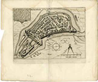
Medium: Engraving/etching on hand laid (verge) paper.
Sheet size: 36.7 x 31 cm (14.45 x 12.2 inch). Image size: 27.4 x 21 cm. (10.79 x 8.27 inch).
Condition: good, given age. Damp staining at the top. Some crinkles or creases. A few minor tears edges, not affecting image. Original fold as issued. . General age-related toning and/or occasional minor defects from handling. Please study scan carefully.
WACHTENDONK-PLAN-FORTRESS-GERMANY | E24-07
BACKGROUND INFORMATION
From: Guicciardini’s Beschryvingh van alle de Nederlanden, edition by Janssonius, Amsterdam 1648.
Biography engraver: Pieter van den Keere (1571?c.1646), Flemish engraver and cartographer active in London and Amsterdam. He worked closely with his brother-in-law Jodocus Hondius and produced historical and military engravings alongside city views and maps.

Reviews
There are no reviews yet.