


Description
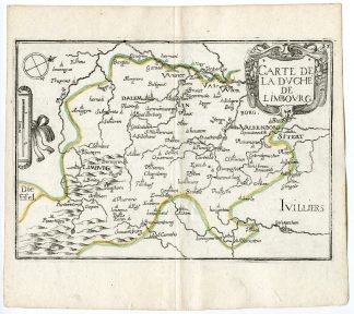
’33. Carte de la Duch? de Limbourg.’
Engraving with outline hand colouring on hand laid (verg?) paper.
Sheet size: 16,5 x 14 cm. (6,5 x 5,5 inch). Image size: 15 x 10,5 cm. (5,9 x 4,1 inch).
From a scarse Atlas: ‘Cartes Generales des Royaumes et Provinces de la Haute en Basse Allemagne.’, by Christophe Tassin, ed. published by Anhoine de Fer in Paris, 1644. This Atlas was first published in 1633. Until 1631 he was engineer and geographer to the French King. In 1644 he stopped working and sold his plates to Antoine de Fer (16xx-1673), the father of Nicolas de Fer (c.1647-1720).
Made by an anonymous engraver after ‘Christophe Tassin’. Christophe Tassin (c.1600-1660), known as Nicolas Tassin, Christophe Nicolas Tassin or Christophe Le Tassin, was a French cartographer and architect, known for his smaller size oblong atlasses.
Condition: Very good, given age. Original middle fold as issued. Some tiny worm holes in margins not effecting image. General age-related toning and/or occasional minor defects from handling. Please study scan carefully.
Keywords: LIMBOURG-BELGIUM-GERMANY
PCO-C24-09


Reviews
There are no reviews yet.