

 Print
Print Description
Copperplate engraving and etching on a verge type hand laid paper. on paper.
Size in cm: The overall size is ca. 72.5 x 53 cm. The image size is ca. 66 x 51 cm. Size in inch: The overall size is ca. 28.5 x 20.9 inch. The image size is ca. 26 x 20.1 inch.
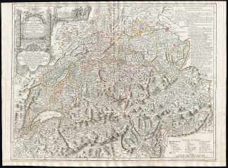
Map: ‘Carte de la Suisse ou sont les treize cantons, leurs allies, et leurs sujets. dress�e sur les meilleurs auteurs et d’apres des observations faites sur les lieux. et publiee par Fran�ois Grasset libraire et imprimeur a Lausanne.’ (Map of Switzerland with its 13 cantons …). Cartouche with the coats of arms of the cantons. Right of the cartouche a historic scene with William Tell shooting an apple off the head of his son. This map originates from an unrecorded composite Atlas compiled around 1795 (based on youngest dated map) which contained many maps originally published in the famous ‘Atlas Universel.’, by de Vaugondy, first published in 1757. To produce the atlas, the Vaugondys integrated older sources with more modern surveyed maps. They verified and corrected the latitude and longitude of many regional maps in the atlas with astronomical observations. The older material was revised with the addition of many new place names. In the late 18th c. the plates of these maps were acquired by Delamarche. This map published by de Vaugondy after Francois Grasset (1723-1789). Artists and Engravers: Gilles Robert de Vaugondy (1688�1766), also known as Le Sieur or Monsieur Robert, and his son, Didier Robert de Vaugondy (c.1723�1786), were leading cartographers in France during the 18th century. Charles Francois Delamarche (1740-1817) founded the important and prolific Paris based Maison Delamarche map publishing firm in the late 18th century. A lawyer by trade Delamarche entered the map business with the acquisition from Jean-Baptiste Fortin of Robert de Vaugondy’s map plates and copyrights and later addes many plates from other sources as well. Charles Delamarche eventually passed control of the firm to his son Felix Delamarche (18th C. – 1st half 19th C.) and geographer Charles Dien (1809-1870). It was later passed on to Alexandre Delamarche, who revised and reissued several Delamarche publications in the mid-19th century. The firm continued to publish maps and globes until the middle part of the 19th century.
Condition: General age related toning and light staining. Worm holes near middle fold and bottom margin. Irregular paper edges, chipped with small tears, backed by identical paper. Short margin at the bottom. regmargined. Please study scan carefully.
Keywords: ANTIQUE MAP-SWITZERLAND-CANTONS-WILLIAM TELL-COATS OF ARMS-GRASSET-VAUGONDY
XXX-B3-12

Reviews
There are no reviews yet.