

 Print
Print Description
Colour lithograph on vellin type paper. on paper.
Size in cm: The overall size is ca. 39 x 28 cm. The image size is ca. 30.5 x 22 cm. Size in inch: The overall size is ca. 15.4 x 11 inch. The image size is ca. 12 x 8.7 inch.
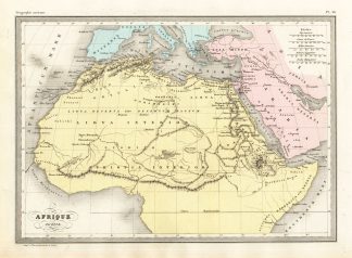
Map Pl. 10: ‘Afrique Ancienne.’ This map shows Africa in ancient times. This original antique map originates from ‘Atlas de la Geographie Universelle ou Description de toutes les parties du monde sur un plan nouveau d’apres les grandes divisions naturelles du globe’ by Malte-Brun and Huot. Published by P. Garnier in France, 1880. The lithographic maps are by Pierre Sarrazin.Artists and Engravers: Conrad Malte-Brun (1755 – 1826), born Malthe Conrad Bruun, was a Danish-French geographer and journalist. His second son, Victor Adolphe Malte-Brun, was also a geographer.
Condition: Good. General age related toning and soiling.
Keywords: ANTIQUE MAP-ANCIENT AFRICA-LIBYA-MALTE-BRUN-SARRAZIN
PCOX-E4-05


Reviews
There are no reviews yet.