

 Print
Print Description
Original etching/engraving on hand laid (verge) paper. on paper.
Size in cm: The overall size is ca. 30.5 x 22.5 cm. The image size is ca. 28.5 x 20.5 cm. Size in inch: The overall size is ca. 12 x 8.9 inch. The image size is ca. 11.2 x 8.1 inch.
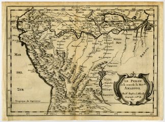
Rare Map: ‘Le Perou et le cours de la Riviere Amazone par N. Sanson d’Abbeville Geographe ordinaire du Roy.’ (Map of western South America). This is a reduced version of Sanson’s important map of South America (1650). Western part of the continent and the full course of the Amazon. The spurious Lac, ou Mer de Parime is prominent as is the location of the mythical city Manoa el Dorado (city of gold). Fully engraved to show topography, cities and villages. This scarse map originates from: ‘Curieuse aenmerckingen der bysonderste Oost en West-Indische verwonderens-waerdige dingen. nevens die van China, Africa, en andere gewesten des werelds.’, by S. de Vries, published in Utrecht by J. Ribbius, 1682. This splendid work on the curiosities encountered during the ages of exploration abroad contains 13 maps by Sanson d’Abbeville and many etched plates by Romeyn de Hooghe, which are considered some of the most interesting of his oeuvre. Ref: Sabin, 19854. Tiele, 260. Cat. NHSM, 240. Muller, 1565.Artists and Engravers: Author: Simon de Vries (Dutch 1524-1708): Poet, writer and translator, publisher, active in Utrecht. Carthographer: Nicholas Sanson d’Abbeville (1600 – 1667) and his descendents were important French cartographer’s active through the 17th century. Sanson started his career as a historian where, it is said, he turned to cartography as a way to illustrate his historical studies. In the course of his research some of his fine maps came to the attention of King Louis XIII who, admiring the quality of his work, appointed Sanson ‘Geographe Ordinaire du Roi’. Sanson’s duties in this coved position included advising the King on matters of Geography and compiling the royal cartographic archive. Sanson’s corpus of some three hundred maps initiated the golden age of French Cartography. Engraved by Antoine de Winter.
Condition: Very good, given age. Middle fold, as issued. Small crease in left margin. General age-related toning and occasional light stains from handling. Please study image carefully.
Keywords: ANTIQUE MAP-SOUTH AMERICA-PERU-AMAZON-CHILE-BRAZIL-SANSON D’ABBEVILLE
PCOX-C7-43

Reviews
There are no reviews yet.