
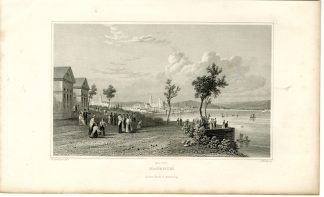
![I-Tierra del Fuego-Le Maire Street [J.S. KLAUBER after COOK, 1795]](https://pictura-prints.com/wp-content/uploads/2019/01/pco-2658.jpg "Pco 2658 416x364")
Description
No. I. Coastal views: Vuurland. Kaart van de Good Success Baai […]. Kaart van Z.O. gedeelte van het Vuurland de Straat van Le Maire […].
Etching / engraving on hand laid (verge) paper. Watermark: M. VORSTER.
Sheet size: 40 x 34,5 cm. Image size: 35 x 30 cm.
From a Dutch ed. of Captain Cook’s voyages: ‘Reize rondom de Waereld door James Cook […].’, 4to ed. published by Honcoop, Allart and van Cleef in Leyden, Amsterdam and The Hague, from 1795.
Made by J.S. Klauber after an anonymous artist. Joseph Sebastian Klauber (1710-1768) was a German miniaturist and engraver of mostly religious subjects from Augsburg. He was a pupil of Antoine Birckhaert in Prague.
Condition: Very good, given age. Original folds from binding. Small hole at folds. Left top remargined, from binding. General age-related toning and/or occasional minor defects from handling. Please study scan carefully.
Keywords: I-TIERRA DEL FUEGO-LE MAIRE STREET
PCO-B1-41


![I-Tierra del Fuego-Le Maire Street [J.S. KLAUBER after COOK, 1795]](https://pictura-prints.com/wp-content/uploads/2019/01/pco-2658-324x283.jpg)

Reviews
There are no reviews yet.