


Description
Engraving on hand laid paper. on paper.
Size in cm: The overall size is ca. 92.6 x 64.5 cm. The image size is ca. 87.4 x 57 cm. Size in inch: The overall size is ca. 36.5 x 25.4 inch. The image size is ca. 34.4 x 22.4 inch.
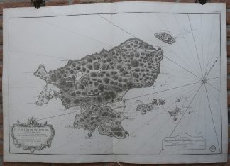
Antique map, titled: ‘Plan de l’Ile de Saint Pierre au Sud de Terre-neuve.’ – A rare detailed map of the island Ile St. Pierre, of the Saint-Pierre et Miquelon islands, Canada. Several smaller islands (Ile aux Marins, Grand Colombier and Ile au Vainqueurs ao.) are also depicted. Depth soundings along the coast. Published by the Depot de la Marine in 1763. In the same year as the Fortin’s map was published, Depot General de la Marine issued a copy of this map, signed by J. N. Bellin. Artists and Engravers: Made by an anonymous engraver after ‘Fortin’. Jacques-Nicolas Bellin (1703-1772) was a French hydrographer and geographer. He is considered the greatest 18 th. c. French hydrographer and for 50 years he was associated with the ‘Depot des cartes et Plans’ (Depot de la Marine) as the First hydrographer of the French Royal Navy. His maps were constantly updated with the latest information and their execution magnificent. Bellin’s major works are the ‘Neptune Francois …’, the ‘Petit Atlas Maritime …’ and the ‘Hydrographie Francoise …’ As a member of a French intellectual group called the ‘Philosophes’ and he contributed 994 articles to the ‘Encyclopedie’ by Diderot/d’Alembert. He also contributed to the ‘Histoire Generale des Voyages’ by Prevost.
Condition: Good, given age. Original middle fold, as issued. Some soiling in the corners, and a soft crease in the center of the sheet. Tiny wormholes in the lower left and right margin corners. General age-related toning and/or occasional minor defects from handling. Please study scan carefully.
Keywords: ANTIQUE MAP-ST PIERRE-MIQUELON-NEWFOUNDLAND-CANADA-FORTIN-BELLIN
(PCO) GK-137


Reviews
There are no reviews yet.