

Description
Chromolithograph on wove (vellin) paper. on paper.
Size in cm: The overall size is ca. 11.9 x 19 cm. The image size is ca. 10.6 x 15.2 cm. Size in inch: The overall size is ca. 4.7 x 7.5 inch. The image size is ca. 4.2 x 6 inch.
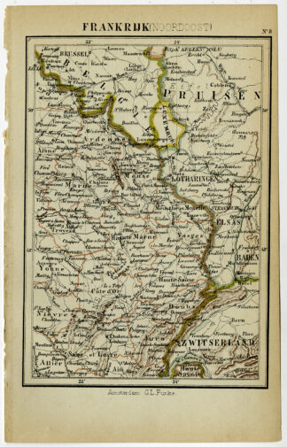
Antique map, titled: ‘Frankrijk (Noordoost).’ – (‘France, northeast). A map of the north-eastern part of France, the region bordering on Belgium, Luxembourg, Germany and Switzerland. Places included in this area are Verdun and Dijon. “Wereld-atlas voor Kantoor en Huiskamer” (transl: World Atlas for the office and living room), by J. Kuyper, published in 1880 – 1882 in Amsterdam, The Netherlands by G. L. Funke.Artists and Engravers: Made by an anonymous engraver after ‘Jacob Kuyper’. Jacob Kuyper (1821 – 1908), Dutch cartographer.
Condition: Very good, given age. Left margin edges a little uneven. General age-related toning and/or occasional minor defects from handling. Please study scan carefully.
Keywords: ANTIQUE MAP-FRANCE-NORTHEAST-VERDUN-DIJON-KUYPER
(PCO) C153-31

Reviews
There are no reviews yet.