
Description
Copperplate engravings / etchings on a verge type of hand laid paper. on paper.
Size in cm: The overall size is ca. 33 x 26 cm. The image size is ca. 29 x 20 cm. Size in inch: The overall size is ca. 13 x 10.2 inch. The image size is ca. 11.4 x 7.9 inch.
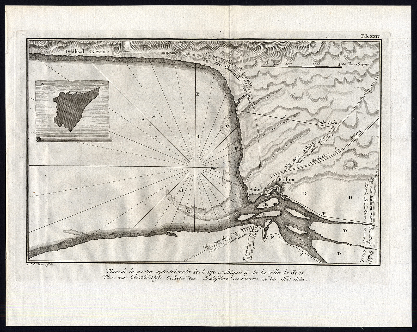
Plate Tab XXIV: ‘Plan de Partie septentrionale du Golfe Arabique et de la ville de Sues.’ (Map of the Northern Arabian Gulf and the city of Suez). This original antique print originates from ‘Beschryving van Arabie uit eigene waarnemingen en in ‘t land zelf verzamelde narigten opgesteld door Carsten Niebuhr. Uit het Hoogduitsch vertaald en vermeerderd met een volledig register van ‘t geheele werk.’, published in Amsterdam by S.J. Baalde and Utrecht by J. van Schoonhoven & comp., 1774. (Translation: Description of Arabia from personal observation and locally gathered information compiled by Carsten Niebuhr, translated from German with addition of a complete register.) This is the Dutch ed. translated and enlarged in from ‘Beschreibung von Arabie…’. published in 1772. Carsten Niebuhr (1733-1815) travelled extensively in Arabia, Persia, Palestine and Asia Minor, and became by his descriptions and maps and the richness of his observations the pioneer of a more profound knowledge of the Orient. Ref: Tiele 795 and 796. Howgego N24. Gay 3589. cf. Graesse IV, 674/ Cox I, 237. Aboussouan 682-683 and Lipperheide Lc6.Artists and Engravers: This plate by C. J. de Huyser.
Condition: Good. General age-related toning. Occasional minimal staining. Original fold. Please study scan carefully.
Keywords: ANTIQUE MAP-ARABIAN GULF-SUEZ-EGYPT-NIEBUHR-DE HUYSER
(PCO) A253-20
![Emblem XVII-Love-God-Cupid-Putti [After SNYDERS, 1626]](https://pictura-prints.com/wp-content/uploads/2019/04/pco-5015-324x497.jpg)
![Medieval Mural of Saints and Apostles [T. T. HOOIBERG, 1846]](https://pictura-prints.com/wp-content/uploads/2018/09/pco-2077-324x304.jpg)


Reviews
There are no reviews yet.