

Description
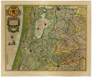
Subject: Antique print, titled: ‘Rhenolandiae et Amstellandiae exactissima Tabula.’ – Map of Rhineland and Amstelland. This map shows parts of Holland in the Netherlands including major cities: Amsterdam, Haarlem, Leiden, Gouda and the Haarlemmermeer, a polder nowdays location of the Schiphol airport.
Condition: Very good, given age. Some stains in print and margin. Print was previously matted, so some discolouring on print. Slight paper separation at lower middle fold. Original middle fold reinforced on rear. General age-related toning and/or occasional minor defects from handling. Please study scan carefully.
Medium: Coloured copperplate engraving. on hand-laid paper.
Size (in cm): The overall size is ca. 55.9 x 46.7 cm. The image size is ca. 50.2 x 40.6 cm.
Size (in inch): The overall size is ca. 22 x 18.4 inch. The image size is ca. 19.8 x 16 inch.
Part Number: 54409
Location: PCO-P8-17
Description: This map originates from a German edition if the ‘Atlas Novus…’ published in Amsterdam by W. Blaeu 1634/1635. Exact ed. unknown.
Artists and Engravers: Anonymous.


Reviews
There are no reviews yet.